Sunday, November 2, 2014

Tahtlum Peak W7W/MC-023 14 September 2014


Directions are from the Seattle Mountaineers book-  Guide to 100 Hikes at Mt Rainier National Park:

Driving:
Drive south on SR 410 and park at Chinook Pass (elevation
5430') on the south side of the road.

Route:
Hike the Pacific Crest Trail south to a high point of 5900' and head left toward Tahtlum Peak. Cross two small bumps and follow the footpath, staying mostly on the ridge or sometimes just to the left. From the summit, a pleasant side trip is to return via Dewey Lakes. From the saddle at 5750', head southward, following easy terrain to reach Dewey Lakes. Return via the PCT. Yet another option is to complete the loop around Naches Peak and return via Tipsoo Lake.

Additional Route Info:  On the return trip at the 5946 ft three way boot track intersection I noticed a well worn track to the west and followed this.  This route turned out to be very well defined and I recommend going this way to the summit.  The beginning of this track is on the PCT (GPS: N46 51.770 / W121 29.772), just past the Mountaineers described route above.    At this point there is a way trail that heads downhill towards a large south facing rock that is popular with visitors.  Head past the rock to find the boot track to the 5946 ft three way intersection at N46 51.817 / W121 28.981.  Ducking through bushy trees is necessary to find the track.  Also, note that Tahtlum Peak is outside of the National Park boundary- which can provide hikers with dogs, horses and (depending on the season) hunters.  

Tahtlum, about 1.5 miles from the TH, the boot track- as described in the Mountaineers book cited above.  It's about 1 mile to the summit from here.
The Garmin map shows my tracks to the summit... and shows the Naches Peak Loop Trail- the popular route for hikers.  

It was a nice cool and clear fall morning when I head out from the parking area at Chinook Pass on Hiway 410. One and a half miles on the PCT to the boot track described in the Mountaineers book.  The track disappeared quite often but following the ridge top leads to a three way intersection 5946 ft.  I regretfully took a left on a well defined track for ¼ mile, but retreated after deciding that since no elevation was gained... then this wasn't the way to the summit. Traversing to the top of the ridge at 6400 ft- the track routes along the north slope of the ridge for about 500 ft to a small saddle.  The summit is a short distance SW.

The summit is stomped down gravel- a flat open spot about 6x6 ft.  Great for 2 meter handy talkie work, but no support for a HF antenna.  The station was set up about 25 ft lower on the north side of the summit.  The 20 ft fish pole antenna mast was strapped to a scrub pine tree which also provided some shade.  The Dan's doublet wires were carefully tied off to other small trees in the scree.

KR7W's station:  KX3, LiPo battery, Log, Easy Chair, picnic basket with wine, cheese, and chocolate truffles- black bears favorite.  

On 2 Meters FM contact was made with a ham at High Rock Lookout (W7W/PL-029) from whom I learned that the ARRL VHF contest was in progress.   I let him know that he was on a SOTA summit.  A couple of hours later on the trek back to the TH, contact was made with Grover, KG7O who had just reached the summit of Mt St Helens.  23 HF QSOs were made.  This days station consisted of:  KX-3 @ 6W, Dan’s 44 ft Doublet, 20 ft carbon fish pole, LiPo 3S battery, Straight Key, and Kenwood D72 APRS handy talkie.

From the summit of Tahtlum other SOTA peaks within a short hike and scramble from the TH can be seen:  Naches Peak- 1 mile, Deadwood- 2 miles, Dewey Pk- 3 miles- shown in photos below.  The routes to Naches and Dewey are described in the Mountaineers book cited above.  Of these, I’ve only activated Deadwood.

Deadwood Pk, about 2 miles to the west.  WA Hiway 410 and the PCT can be seen at its base.  

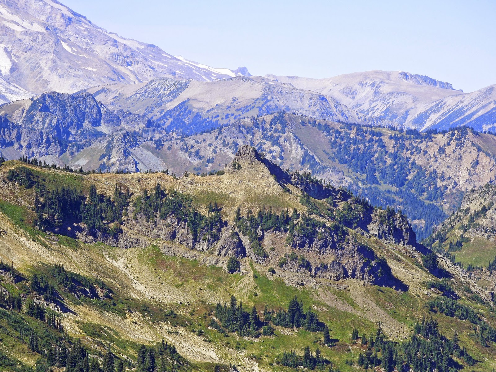
Naches Pk is seen looking west.  The popular Naches Pk Loop Trail circumvents this peak.

A popular Hiking and Backpack destination is Dewey Lake to the south.  SOTA's Dewey Pk is above the lake.  The Peak to the right is non-SOTA Seymore Pk.
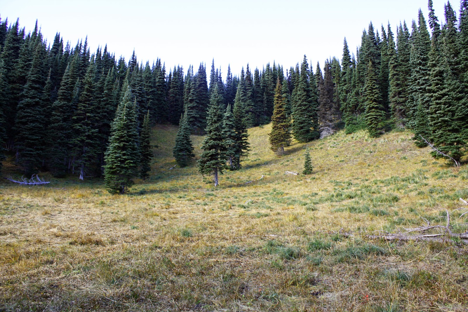
On the trip to the summit very few hikers were seen.  The return trip provided at least 40-50 visitors walking the PCT to Dewey Lake and the Naches Peak Loop trail (in Mt Rainier National Park).  This area is great place for hikers to go for a walk in the woods.


72  Rich KR7W


Wednesday, October 29, 2014

Tamanos Mtn – W7W/RS-015 – 24 August 2014

Tamanos Mtn, in Mt Rainier National Park is accessed via the Owyhigh Lakes Trail, either from the White River Road TH or the Deer Creek TH along Hiway 123.


Tamanos as well as some other SOTA summits can be seen from the Sunrise Visitor Center at Mt Rainier National Park.  This photo was taken from the Sourdough Ridge Trail.
Ms Pat WT7N and I decided combine this summit activation with a three day - two night backpacking trip.  From the White River TH we hiked this popular trail 3 miles to Tamanos Creek BC Camp (permit must be acquired at the White River Ranger Station).  

The Garmin map shows our route from TH to BC camp to Boot Track up to the Tamanos ridge.  The Owyhigh Lakes on the map is the popular destination of visitors in this area of the National Park.
The next morning we continued south towards Owyhigh Lakes.  About ¼ mile further is an open meadow at the apex of the trail at 5350 ft. The non maintained but obvious boot track to the summit begins here.  [Note:  At this point- APRS works flawlessly]  From the meadow we ascended up the side slope to the top of the ridge at 6280 ft in 4/10 mile.  Then we followed the ridge south for ½ mile to the summit at 6700.

There are two rock bumps on the summit that remind me of steam ship stacks which can be seen from afar at the right angle.  We did not climb onto the rocky stacks but were within 20 vertical ft of the summit.

Substitute Fishpole mast about 6 ft high.  A trek pole was used to place the Dan's Doublet center insulator at the highest point.
I had left my 21 ft carbon fish pole antenna mast in the car and became concerned that I’d have to make radio contacts with the antenna strewn on the rocks. The problem was solved with a scraggly dead tree about 5 ft high that became the apex for my Dan’s 44 ft Doublet antenna.

KR7W at Op Position.  Rig is KX3, 3S LiPo battery, Russian SK, Dan's 44 ft Doublet Antenna w/ Balun, Kenwood D72 APRS HT.  There's a red microphone that almost never gets used.
In the middle of the activation I looked up and noticed dark bottomed storm clouds.  “QRT BAD WX” was sent a few times and I went QRT.  Some kind chaser spotted me on sotawatch that I was QRT due to bad WX- a tip of the thank you hat to you kind madam/sir.  We quickly picked up and head back down.  At our BC campsite the rain started.  We quickly broke camp and headed to the TH in progressively worse rain.  Flash-Boom!  A lot of lightning and thunder- one strike ¼ mile away was scary too close.

Mt Tahoma (aka Lil Tahoma) looms really close to the west.  Looks like rain clouds coming in.
Looky here- Governers Ridge looms to the east.  In the valley between the ridge I am on and Gov Ridge is Owyhigh Lakes and the trail.
From the 6380 ft point on the ridge... Double Pk and Shriner Pk can be seen.  Both are SOTA destinations.
Our second night was to be spent at Dick’s Lake BC Camp in the Palisades area… but we took a rain check.  
End of Blog.  72   KR7W

Wednesday, October 22, 2014

W7W/RS-008 - Palisades Pk - 28 September 2014


A view from approx 1/2 mile into the hike shows Palisades.  We hiked up to the saddle between Palisades and the peak to the left (Marcus Pk).  Hidden Lake is hiding below the rocky face of Palisades.
Directions are from the Seattle Mountaineers book:  Guide to 100 Hikes at Mt Rainier National Park:  

Driving
Drive SR 410 4.5 miles south of the Crystal Mountain ski area turnoff and turn right on Sunrise Park Road. Drive 13 miles to Sunrise Point. Park in the large parking lot (elevation 6100').

Route
From the east end of the parking lot, take the trail toward Sunrise Lake but turn north on the trail marked Palisades Lakes.  Continue on the trail, and before reaching Dicks Lake come to
a sign for Hidden Lake. Turn left on this trail and follow it past the lake; then ascend to the saddle between Marcus and the Palisades. At the saddle, head north and approach the
high point over a gentle slope. It may be slightly easier to go beyond the summit and double back on the northwest ridge, as this avoids some thick vegetation".


Red dots that begin at the saddle X above Hidden Lake, elev 6500 ft, show the off trail route to the summit. 
 Ms Pat WT7N and I followed the boot track from the Lake to the top of the Saddle X we pushed through thick bushy trees into a large meadow which revealed the route to Marcus Pk.  But instead, we ascended the meadow north, found an opening in the thick trees and headed upward toward the top of Palisades.  We zig-zagged upward avoiding the thick clumps of trees for approx 400 vertical ft.  We ended up on a saddle- about 40 vertical ft below the highest of the two bumps that make up the summit where I uttered, like pioneers before me, " It is enough. This is the place!"  at 1245 PM LT.  


This view is from Hidden Lake- looking upwards to the top of the 6500 ft saddle.


Looking down to Hidden Lake from (almost) the top of the saddle.


KR7W- in the meadow to the west of the top... pondering the route up the next 400 vertical feet to the summit.

On the summit saddle it was easy to attach my fish pole mast to a scrub tree and then carefully fan out the antennas wires in the scree among the scrubby trees.  I propped my 2 meter coaxial vertical antenna in a bush and set the D72 APRS Handy Talkie on a rock next to my operating position.


KR7W using straight key for CW.  Rig is KX3, Antenna is Dan's 44 ft Doublet + Balun, mast is 21 ft carbon fishing pole strapped to tree (above kr7w's head).  Kenwood D72 for 2 meter comms + APRS spotting.
Looking SW, a view of Mt Rainier on the west side of the saddle on the summit.
Looking west- a grand view of Grand Park - from the summit.
40M CW was produced 6 QSOs- which is a lot, 5 QSOs on 30M, and 15 QSOs on 20M.  4 QSOs on 2M FM were made interleaved between HF QSOs.  I again was amazed by 2M contacts.  A newbie ham in Lacey with a $40 HT- 57 miles away, A ham in his living room in Ellensburg- 50 miles away, and to a ham operating a remote base near Nassele, WA- 112 miles away.  I could have made many more contacts but time ran out.


Mountain Goats grazing.  Must be good eats in those rocks.
The trip down was almost uneventful- we saw mountain goats grazing on the rocky slopes above Hidden Lake... and there were lots more people on the trail on this beautiful fall day.  Some hikers spotted my collapsed fish pole and/or my 2 meter coax dipole in the pockets of my pack.  Some would ask, "Hey, what's that for?" I'd reply that I am a ham operator participating in SOTA (and explain that).  Some would ask, "What's the furthest station you contacted?".  I'd say, "NJ or NH or TN".  I actually knew where because more and more chasers are including their STATE in the contact exchange.  A tip of the appreciation hat to Chasers who take the time to do that!


On the return hike... we stopped at Clover Lake- about 1.5 miles from the Trail Head.
Next year I will be back to set up my tent for a few days at Dick's Lake back country camp and will attempt to summit Palisades and Marcus Pks from a base camp.  I am looking forward to that.

Photo credits:  Pat WT7N.

A quick movie of this outing:
https://www.dropbox.com/s/rltzsukji0a5xic/Palisades%209_28_2014.wmv?dl=0

End of Blog.  72   Rich KR7W


Monday, October 20, 2014

W7W/RS-029 - Scarface - 19 October, 2014

19 October, 2014   Scarface   W7W/RS-029

Directions to the TH are from the book '100 Peaks in Mt Rainier National Park' by the Seattle Mountaineers:

"Drive to Enumclaw, WA and head east on SR 410 toward Mount
Rainier. Turn right on FS 73 and drive 10 miles until you
reach Eleanor Creek. At this point the road is almost directly
on the northern border of the park. There is a sign on the left
side of the road marked “Eleanor Creek, elev. 4520.” Park just past the sign".

Our goal for this outing was to hike the E-W ridge west to the summit, do the SOTA thing, hike the N-S ridge south to the Grand Park Trail, enjoy the views as we hiked back to Lake Eleanor. 

It's 100 yards to the National Park boundary and one mile to Lake Eleanor on a boot track originally made by fishermen.  Hike another 4/10 mile on the National Park trail to Grand Park to the base of the E-W ridge ('Scarface X' on map below) up towards the summit of Scarface.


Very scenic Lake Eleanor.  Scarface is top center in this photo.  

Here's the GPS Tracks of the Hike
CAUTION:  Before I go any further... The Mountaineers book I cited above rates this climb with a difficulty level of 2 (out of 5).  I personally think it is a bit more difficult.  Also, I do not recommend going to this SOTA summit unless the seasoned hiker possess decent route finding skills.  The hike is mostly in dense forest with very few landmarks to sight to. A GPS with an adequate map is highly recommended.


The hike along the E-W ridge is about a mile.  There's hundreds of blown down trees to navigate around.  If I interpret my GPSs stats correctly... the one mile straight line route ended up being approx 2.5 miles of walking.


Here's a looky up the E-W ridge.
Taking a rest to change GPS batteries- still on the top of the ridge. The blow downs are plentiful for the next 1/2 mile.
We followed the ridge for 3/10 miles until a large rock outcropping detoured us to trek along ascending the steep ridge at approx 100 ft below the ridge line.  Because we are not on top of the ridge- we are walking at a steep angle. 


Here's a shot at the summit destination about 4/10 miles away- as seen from the top of the ridge.  It's easy to see why John Muir or early Park visitors named this peak "Scarface".  
The map shows a 'bump' at 5800 ft along the ridge.  After passing under the bump, we hiked up 30 V ft to see what we could see from the ridge top.  The above photo shows our destination.  At this point I am somewhat discouraged because it's taking more time than I budgeted and we aren't close yet.


We are out of the woods... so to speak... as we enter this clearing where the E-W ridge meets the N-S ridge.  It's an easy (as compared to blown down log hopping and walking at a 45 deg angle) 2/10 mile and 300 vertical feet to go.
We arrived at the true summit about 50 minutes later than I estimated.  I began the activation with 2 meter FM and attempted to make comms with hams in Tacoma.  I was barely heard on the club repeater.  My only contact on 146.520 was with a ham driving through an espresso stand in Mt Lake Terrace, WA, north of Seattle, 63 miles away.  Also, there were no APRS comms until I reached the summit.  


A rarely seen frontal view of KR7W at the key.  BTW- the old Russian Cold War key that broke down on the last activation was repaired and is back in service here.  The radio is a KX3 at 6 watts.  The antenna is a Dan's 44 ft Doublet with 4:1 Balun.
HF propagation was sketchy due to a CME, so I had to cut the activation short after 10 QSOs to be sure to have enough daylight to safely get back down the N-S ridge and then to the National Park trail back to Lake Eleanor.


The views on this hike were not plentiful... but here's a shot of Lake Eleanor from the very edge of the summit- near the scarred face.
The trek down was nice at first as we walked on game trails along the N-S ridge.  We ascended a high bump on the ridge for the views and could see Grand Park and some of Mt Rainier.


Here's a shot of Grand Park with Mt Fremont towering above.  The Fire Lookout cabin is seen if you squint just right.
After passing the bump we ended up on a rocky drop off.  At this point we had run out of time to follow the ridge down to Grand Park.  We descended east following the lay of the land hoping to intersect the National Park trail back to Lake Eleanor. The lay of the land took us to many detours around trees and rock formations which resulted in the 'not the most direct way' to the trail.  A mile on the Nat. Park trail to the lake and another mile to the car gave us one hour of daylight left.

Credits:  Hiking partner Ms Pat WT7N for the photos and encouragement to keep going to the summit after the going got tough and frustrating for me.  Thanks to chasers for the QSOs and waiting for me.  

End of Blog.  72, KR7W


Friday, November 29, 2013

W7W/KG-073 - Bandera Mtn - 28 October, 2013

28 October, 2013    Bandera Mtn    W7W/KG-073

Our original hiking destination for this day was going to be 7000 ft Norse Peak, an 8 pointer, near Crystal Mtn Ski Resort, a bit north and east of Mt Rainier National Park.  The Mt Rainier WX report predicted 30-40 MPH winds at Paradise and Camp Muir in the National Park.  We took off for our backup hiking destination:  Bandera Mtn.

Readers note:  This text has been edited to clear up a misunderstanding I had about the "Activation Zone".  'Added note' Corrections below...

Directions are here:  http://www.wta.org/go-hiking/hikes/bandera-mountain  The WTA trip description is not entirely accurate.  I suggest the SOTA activator read a few trip reports for additional info.

This days outing was for me and Ms Pat WT7N to hike the Ira Spring Trail towards Mason Lk.  If it was overly windy then we’d continue onward to Mason Lk for the views.  At the fork in the trail there was little or no wind… so off to Bandera we went.

From the intersection the Bandera trail is an unmaintained boot track that ascends almost straight up most of the way to the View Point, called Lil Bandera on my Green Trails map.  My GPS said the elevation here is 5140 ft ASL.  This spot is very scenic and the warm sun on a cool day was inviting.  I wanted to operate my radio from this point.  I knew I was approx 60 ft from the true summit but I couldn’t remember how low the activation zone was.  So it was decided to press on the remaining .8 mile to the true summit. 

 It wasn’t obvious to us how to proceed to the true summit from this spot.  Then a hiker and his dog came by and continued on downhill (which defies my mountaineering training of avoiding losing elevation whenever possible).  We followed him until he decided to turn back.  The trail looses about 200 ft of elevation to a low point on a saddle.  The climb back up was one of those hikes where it’s handy to grab tree branches.  After following the faint rabbit trail a ways…  Garmin said we were 500 linear and 20 vertical ft from the proper summit.  At this I proclaimed, sort of like I imagine Brigham Young proclaiming, “This is the place!”  


The Green Trails map was correct by saying, “No views”.  Peering through the tall trees I could just make out the top of Lil Bandera and Mt Defiance.  Not much sunlight made it through the trees for warmth while being surrounded with snow that hadn’t melted from last week’s storm.  The bonus is that the insect population had frozen to death.


Station set up in No View Trees

I was glad we stopped at this location because I could hear the group of young men who began their hike from the TH just before we did.  They were on the true summit being primal and un-stressing by making blood curdling animal sounds.  I wanted to walk over and tell them how ridiculous they sounded but instead I focused my energy on making 29 CW contacts on 7, 10, and 14 MHz as well as two difficult dot five two FM QSOs.    After 45 minutes we decided to pack up and leave because we were getting cold in the 'no views' shade.

The return route down to the saddle and back up to Lil Bandera was a different path than our arrival route.  The trail was sometimes lost but easily found.  I always had the top of Lil Bandera in sight so I never felt lost.  A couple of times it took some effort to push through branches only to find we should have zig zagged another way.    The route from Lil Bandera down to the Ira Spring trail required some concentration to place each step carefully but with trekking poles navigation was easy without falling down.   Once on the Ira Spring trail to the TH it seemed like a six lane freeway in comparison.


From the Lil Bandera false summit... Mt Defiance (W7W/KG-043) is seen in the distance.

Once back home I re-read the SOTA ARM manual for W7W/WA.  The summit operation area or Activation Zone is 30 vertical meters (98 ft) from the summit.   If I had it to do over again I would have operated from the top of Lil Bandera which is 60 ft below the summit and well within the AZ. 


Rabbit trail route on the saddle between Bandera summit and Lil Bandera.

Added Note:  Above I mention that Lil Bandera is in the AZ... after careful reading, I think I understand that Lil Bandera is NOT in the AZ.  The UK's General Rules, section 3.5.2 states, "the terraine between the Operator Position and the Actual Summit must not fall below the permitted Vertical Distance."

Added Note:  The WA SOTA ARM manual does not use the term Vertical Distance... but I think this text from the WA ARM (sec 1.3, para 2)  manual sums it up: "Another way to describe the AZ is any plact that has a route to the summit point that does not dip below 30 meters of the summit point"...


Summary with recommendations:  I liked this hike because the WX was right for it and it was challenging without over doing it.   When I go back I will probably activate Mt Defiance first and if I have energy on the way back… hike the short but steep boot track to Lil Bandera and activate from there.  My Mt Defiance trip report:  http://kr7w-sota.blogspot.com/2013/07/mt-defiance-w7wkg-043-july-19-2013.html

Be aware that there’s not much room on top of Lil Bandera for lots of view seeking hikers and a SOTA HF operator.  But it should be easy to get four 2 meter QSOs into Tacoma, North Bend, towards Eastern WA.   To navigate the big rocks and gully of a trail from the Bandera trail turn off to Lil Bandera I highly recommend trekking poles.  This trail has southern exposure so extra water is important.   


End of Report

-30- KR7W

Monday, November 25, 2013

W7W/MC-026 Goat Peak

13 October, 2013

I was once told that there are 61 Goat Peaks, Creeks, Ridges, Lookouts, and Lakes in my great state of WA.  

This particular Goat Peak is located just east of the Cascade Crest here in WA State. 

Myself, partner Ms Pat WT7N, and Bro Mike drove 19 miles east of Chinook Pass on Hiway 410 to one of the three Goat Peak THs.  Our TH is located directly across the highway from the Hells Crossing Camp Ground.  Garmin said that the distance to the summit was 3.2 miles with an elevation gain of 3000 ft.  BTW, we did not take the
http://www.wta.org/go-hiking/hikes/goat-peak-1  recommended route.


The three of us had visited Goat Peak a few years before- long before I knew about  SOTA.  Back then we hiked to the summit in almost rainy conditions and didn’t see much except for some old fire lookout phone insulators nailed to the trees.   This trip we were rewarded with a lot of nice scenery on a cool clear warm in the sun fall day.

From our chosen TH at 10 AM, where the temp was 28 deg F, we began gradually ascending in meadow like terrain.  But soon we were climbing up a gully with a creek in it.  The going was rough for ¾ mile climbing over and around rocks.  After that the trail is OK to do business on.  We encountered a bit of snow, left over from the previous week, on the trail between 5,000 and 5,500 ft elevation.  This snowy area of the trail was along the north side of the ridge in the shadow of the sun. 

The beginning of the snowy trail

I was a bit confused when we came to an intersection where the WTA trail meets our trail which was about  ½ mile from the summit.  I was thinking at this point there would be a spur trail to the summit.  But no… our trail and the WTA trail converge to create the American Ridge Trail which routes within 50 ft of the Goat Pk summit and keeps on going southwest towards the PCT. We encountered a party of three humans and two annoying canine hikers in a snowy area who were heading back down.  We had the whole summit area to ourselves.  Fine Business. 

The actual summit is a large flat surface approx 20 x 20 ft where the fire lookout cabin used to sit.  There was no place to strap or jam my fish pole mast into so I opted to set up my station 40 ft downhill a bit off the beaten path.  But first I wanted to operate on 146.520 FM.  I had pre-programmed some Yakima repeaters into my 2M HT and called for ops to QSY to dot five two.  A long enjoyable QSO was had with a ham on a Yakima Ridge and another with a ham on Whiskey Dick Mtn near the Columbia River close to Vantage.  I am always amazed by 2M DX.


The summit about 40 vertical ft above the trail.  The old fire lookout stood atop this big old rock.
Admission of error:  I should have listened on the frequency before I spotted myself on 14.061… as this frequency had some other SOTA activity on it.  I could faintly hear another activator and the very loud QRO signals of the chasers.  I couldn’t make out the summit’s call sign due to the strong chaser signals.  I wondered if some chasers might think that they made contact with me because of my error.   I moved to 30 Meters and made 10 QSOs.  Then back on 20 Meters there was still activity on 14.061 and I still couldn’t get the activator’s call sign.  I moved to 14.065 but did not spot myself.  It took a many CQs to finally make a contact.  I must have been spotted by another chaser or RBN and then 27 QSOs were made.

It was such a nice sunny day basking in the southern sun I’d walk away from my radio and hike up to the fire lookout location just to look around and chat with my hiking companions.  I was in no hurry to leave.  But backcountry common sense took over and we packed up our stuff, but a bit later than I’d usually do.  It was just getting dark just as we approached the TH.  


The snowy trail on the way back to the TH.  Bro Mike wears his ORANGE because it's hunting season in WA state.
Epilog:  Just the other day while hiking to another SOTA location… I was thinking about all of the SOTA outings I’ve been on this year… and if I had to pick one of them that stand out as my favorite… It would have to be this trip to Goat Peak.   

Here's a few Flickr fotos that show some SOTA radio activity:http://www.flickr.com/photos/kr7w-sota/sets/72157638048325035/


73  to all.
-30-
Rich KR7W

Wednesday, October 9, 2013

W7W/PL-029 High Rock Lookout

Sunday, Oct 6

After experiencing the beginning of the 2013 Flu Season for a week... taking a short hike on a nice clear day would be good medicine.  

High Rock Lookout is a popular 3.5 mile RT jaunt that gains 1400 ft.  I will be the seventh SOTA op to activate this peak.  This location is touted by outdoor photographers as the 'cat's meow' for mountain photographs.  Also, this hike seems to attract those hikers (you've seen them)  with no pack or jacket and only a bottle of water.


Pat WT7N and I had been to High Rock before but in the rainy fog with 30 ft visibility.  For this days hike it was clear with superb
 views of Mt Rainier looking north.  Mt St Helens, Mt Adams, and Mt Hood are to the south.  Nearby is the Tatoosh range with 4 SOTA summits and further to the east is Goat Rocks with SOTA's Ives Pk.  

According to Washington Trails Assn there are two ways to get to the TH at Towhead Pass.  The Family Sedan way and the nondescript way.  See:  http://www.wta.org/go-hiking/hikes/high-rock   The nondescript route was shorter but way harder on my Subaru.  The return trip via the easy-peasy Family Sedan route only had a few potholes to avoid instead of sinkholes. 


If you squint just right the white lookout cabin is seen on the tip of the big rock.  The drop off is about 600 ft.  

The hike is on a beaten path up a ridge back which ends on a large rock face.  A few hundred feet up the rock is the lookout cabin perched on the very end with a sharp drop off.  The cabin had its shutters down but the door was open for touring.  All of the usual lookout equipment was missing.  


At historic lookouts I don't like to use the structure for my antennas so I am not in the way of other visitors.  I would normally find a spot away from where the visitors are going to hang out.  But here, there are few options.  I strapped my 18 ft fish pole to an old hand rail support.  To tie off the strings on the ends of the doublet antenna... It was difficult to find cracks in the smooth rock face to jam the string winder into.

In my thinking... there's no such creature as 'Murphy' (as in Murphy's Law)... but there is complacency.  Complacency on my part revealed itself when I couldn't get my radio to transmit.  All the controls and settings looked right.  I could TUNE, I could hear myself send Morse, but I had no RF Power output indication.  After a few minutes of dinking and rebooting... I remembered that at home I had the radio in the code practice mode which shuts off the RF.  It took me a while to recover from that.  Phil NS7P kept sending ?? after I TUNEd up on 7r032 which is where I APRS spotted myself.  We finally made the contact and I sent: SRI TECH DIFF HR.  I tried 40M SSB, but the popular CA QSO party in full swing.  3 QSOs were made on 30M CW.  20M CW was the most fruitful with 22 QSOs. 


Fish pole is strapped to an old handrail stanchion.  This spot was the furthest from the cabin where I could set up and still be in the obvious activation zone.  I was lucky to find cracks in the rock face to jam the antenna wire ends string winders into.   

 Safety First- As soon as I saw groups people coming up the rock slope I shut down and dismantled my antenna.  It was too close for comfort on top of the steep rock for lots of hikers and strings and wires.

Highlights from this outing:  I made contact with avid Ped Mobile QRPer W0RW. No slash P was heard so I suspect he was at home.  At 1914 Z contact was made with WG0AT.  I notice on Sotawatch that he was on top of Mt Herman a few hours later.  Steve moves fast.  The big enchilada of contacts for me was with G4oBK.  Loud signals each way.  That's the first NON North America SOTA contact I've made.  I noticed new call signs in the 'SOTA Chaser Community'- because I was early to my activation? Maybe, but I betcha it's due to more folks getting involved with SOTA.  


Fotos and a non prime time short movie can be seen here:
http://www.flickr.com/photos/kr7w-sota/sets/72157636327717146/


End of Report.  Best Regards and Happy Trails,
Rich kr7w
w7w/rs-nnn