Sunday, September 22, 2013

W7W/RS-005 - Mt Fremont - 30 Aug, 2013

Prologue:  In 2012 I retired from many years of Telecommunications and Mobile radio work.  January 2013 I became a volunteer (one day a week) at Mt Rainier National Park in the telecom-2 way radio shop.  During the summer months I have been hiking to the Park's four historic fire lookout buildings to perform radio system repeater upgrades.  Each lookout is located right on or next to a SOTA summit.  Sometimes it's easy to combine work and play.  


I did not take a camera on this trip, but here's the historic lookout building from afar.  The actual summit route is to the right side of the foto.  .  This foto was harvested from the WWW.

On a foggy Aug 30 my supervisor and I hiked to Mt Fremont Lookout to upgrade and perform maintenance on the radio system.  After the work was complete we hiked to the proper summit of the mountain.  From the lookout, 1/10 mile south and 140 vertical feet, got us to the top.


This view, looking north, is from the Frozen Lake intersection of many trails.  The actual summit is about 3/4 of the way over from the left, horizontally in the middle.  The trail along the mountainside leads to the lookout, which can be seen if you squint or press CNTL + .  This foto was harvested from the world wide web.

Armed with a 2 meter handy talkie attached to my coaxial dipole antenna - we took turns calling CQ SOTA on 146.520.  I made 7 QSOs.  One as far away as Aberdeen, WA... which is very close to the Pacific Ocean.  I'm still amazed and pleased about the number of hams who monitor six-five-two and who want to make the QSO with the far away ham.


Mt Fremont is not a drive close to the summit kind of activation... but is a pretty easy summit to achieve 8 points if the activator is willing to do the hike.  The scenery is spectacular too.  Info on this hike can be found here:  http://www.wta.org/go-hiking/hikes/mount-fremont-lookout


End of report.  Rich, kr7w

Monday, August 19, 2013

W7W/RS-012 Pyramid Peak 8/14/2012

Prologue:  Tuesday, Aug 12, Myself, Ms Pat WT7N, my Bro John KF7MYI, and Chuck AC7QN began a four day backpack trip in Mt Rainier National Park along the Wonderland Trail to the Indian Henry's Hunting Ground and Emerald Ridge areas.  Indian Henry's is a large meadow with four good sized peaks surrounding the meadow outskirts.  Three are SOTA Peaks- which the map shows highlighted in yellow.   Hey, you are right if this sounds familiar. 


Chapter 2:  It's Wednesday AM and us four hikers are off to the meadow in search of SOTA peaks.  I opted to activate Pyramid Pk and Ms Pat and Bro John want to give the hike a try also.  Chuck has opted for Iron Mtn.  Pyramid is on the far east side of the meadow and Iron (right next to Copper Mtn) are in the middle of the meadow.  After a quick lunch and safety meeting at Mirror Lakes we split up.


Pyramid Peak looms across the meadow.  Part of Iron Mtn can be seen on the R side of the foto.

The WX is very pleasant with a high ceiling and no direct sunlight.  The temp is 60-65 deg- great hiking conditions.  As we hike across the vast meadow we are surrounded by gorgeous wildflowers and relentless BUGs.  We are all wearing our mosquito bug hats... which for me distorts my depth perception. 

After about an hour of walking, it's 1330 LT.  Time to make handy talkie radio contact with Chuck AC7QN somewhere on Iron Mtn.  Chuck reports that he had a too difficult time going up and is heading back to our campsite at Devils Dream.  Also, on frequency is Casey WW7CH at the National Park radio shop.  Casey plans to be in communications with us on 146.52 as well as watch my APRS tracks on aprs.fi.  

KR7W Makes 2 meter contact on 146.52 per the safety meeting discussion.  My elevation is about 6100 ft.
Fish Pole mast is guyed 1/3 the way up.  44 ft doublet extends N-S with mason string tied to rocks.  If there is any directionality - it would be E-W.

1430 LT, we are on the summit.  Wow! what a climb.  What a view!  At 1451 LT the HF Station is OTA.  There are no trees on this summit.  Just some goat trimmed grass, sort of like a lumpy lawn.  Rocks provide decorations and means to hold the fish pole guy lines down to the earth... as well as secure the ends of the 44 ft doublet Inverted Vee.  The only thing that wudda made this place better would be lawn chairs.


Nice soft rocks and grass- actually it was pretty comfy.  Fish pole mast is on R.  D72 APRS HT is next to KR7W's  R elbow.


I figured that we had at least a three hour walk back to our campsite... so I set a "Let's start putting it away" time of 1530 LT.  I went directly to 20 meters because of its success with the previous activation.  Eleven 20M CW QSOs and six 2M Qs were made.  A lot of the 2M Qs were made while we were tearing the HF antenna farm down.  It's always amazing to me that there are lots of folks monitoring 146.52... and I am glad that they do.  

The hike down the steep scree slope and the rest of the way to the meadow went pretty quickly.  Myself and Bro John slipped on the steep muddy trail a few times.  Once in the vast meadow the trip was a long slog.  For some variety we decided to stop at the Ranger Station Patrol Cabin in the meadow to check it out.  Volunteer BC Ranger Phil was on duty and he showed us around the cabin.  He mentioned that the WX report suddenly changed and that a low pressure front would be visiting us with rain for a few days. 


Here's the Patrol Cabin / Ranger Station.  My Bro John chats with VIP BC Ranger Phil. 

Check out the high snow level entrance door.  Phil says that there was 6 ft of snow here this June.

The next day was Thursday- the day we were scheduled to hike out of Devils Dream Camp to Somewhere.  The plan was for us to hike across Emerald Ridge (the most scenic part of the Wonderland Trail, IMHO) and to South Puyallup Camp to spend the night.  OR  We could hike back to the car.  The best choice for everyone was to hike to the car.  The skies were rain free whilst we packed everything up... but as soon as we beat feet the 6 miles to Longmire we caught rain most of the way.  


Here's our campsite at Devils Dream Camp the day after the trip to Pyramid Pk.  Ranger Phil was right about the WX change... as it rained on us all night.  


Epilog:  My apologies to the Chasers who followed my APRS tracks which had the wrong status message- which said that I was heading back to the TH instead of to W7W/RS-012.  Of course, Thanks to the Chasers for being there to help make this somewhat difficult activation successful.  Last thing:  Sorry Phil that I didn't operate on 40M this time- as there was a lot to do in a short time and I just didn't think of it.   

Flickr photos with captions can be seen here:
http://www.flickr.com/photos/kr7w-sota/sets/72157635145237964/


Happy Trails to You... Until we meet again.... on 14.061.

Rich kr7w


W7W/RS-033 Mt Ararat

Prologue:  Tuesday, Aug 12, Myself, Ms Pat WT7N, my Bro John KF7MYI, and Chuck AC7QN began a four day backpack trip in Mt Rainier National Park along the Wonderland Trail to the Indian Henry's Hunting Ground and Emerald Ridge areas.  Indian Henry's is a large meadow with four good sized peaks surrounding the meadow outskirts.  Three are SOTA Peaks- which the map shows highlighted in yellow.


Chapter 1:  Pat and I arrived early (about 2 PM) at Devils Dream back country campground and claimed our site by setting up our tent.  At 3 PM we agreed to head up the trail 1.1 miles to Indian Henry's meadow which is the beginning of the ascent to the top of Mt Ararat.  Garmin showed the climb to be about 800 ft elev gain in 3/4 mile.  My plan was to walk the Kautz Creek Trail until the apex was reached and then head up Ararat.  Why walk through brush when there is a trail some of the way?  Turns out that the route up Ararat from there was up a rocky face.  So we retreated back down the trail to a less steep approach according to Garmin.


Mt Ararat viewed about 3/4 mile east of the base.  The rock face with drop off can be seen in the center near the top.

Back in the  the 80's I'd trekked to the top of Ararat twice.  One of those outings I camped on the summit for two days to explore, to find the Ark, see flying saucers at night and hear and feel large ice chunks fall from the nearby glaciers.  Back then it seemed like an easy trek down/up to fetch water... but I can tell ya 30 years later that those trees have grown taller, the brush is thicker, and the slope is way steeper.  We headed up a rocky gully.  When that gully ran out we were in a sloping meadow, then another gully and it repeats until we reached the vast flat topped summit where a small plane could land.  The highest point looked to be 1/8 mile to the west... but Garmin said we were on the summit +/- 10 ft.

I figured out that a few folks musta been following my APRS tracks because as soon as I circled the the top of a small knoll to find a comfy spot... I began to receive calls on 146.52.  The fish pole mast was strapped to a snag tree, the 44 ft doublet was hung in an inverted Vee fashion, and radio set up in the shade.  OTA at 0004 UTC the next day.

The mosquitoes and biting flies were extra pesky and contributed to my Morse being extra sloppy.  


On each band I spotted myself via APRS to call sign-SOTA.  Only one Q on 40M- with Phil NS7P- who is always in my log, it seems. 4 Qs on 30M. When I got to 20M, I sent dah-dit-dah-dit-dah on 14.061, I was greeted with a cacophony of callsigns- pretty amazing.  15 Qs on 20M CW were made and many more that could be made but I had to shut down in order to have enough time for me and Pat to safely retreat down to the meadow and back to camp.

I decided to follow the 80's route down- due east- with the patrol cabin in sight- which took us to a rocky face with a drop off.  Uphill was needed and zig-zag to the south then down a series of gullies and in 45 minutes we were back to the meadow and the trail back to camp.  


Back in the meadow the National Park Service patrol cabin can be seen.  Some years this meadow can have 6 ft of snow in it in June.  This view of Mt Rainier shows the Tahoma glaciers.  
Thanks to the Ionosphere gods who made for low noise - high E layer propagation radio contacts during our outing.  Thanks to the chasers who waited until late in the day to make contact.  I am sorry we couldn't stay there longer and make more QSOs.

Flickr fotos with comments can be seen here:http://www.flickr.com/photos/kr7w-sota/sets/72157635130064235/


Best Regards,
Rich kr7w

Sunday, August 11, 2013

I Was 34 Years Old Again - SOTA Activation of Silver King Mtn - W7W/RS-010

Sunday, Aug 4, 2013, Myself, my partner and hiking companion Pat WT7N, and Chuck AC7QN head off to Mt Rainier National Park (WA State) with full backpacks for an overnighter in the BackCountry.  The main goal was physical conditioning with a full pack to prepare for 'the big hike' the following week- a shake down outing of sorts.  Where we were going to camp was based on BC campsite availability within the White River Wilderness area of the Park.  I had 3 BC choices, where two offered SOTA peak access.  With SOTA possibilities... we took our radio equipment.


This annotated trail map shows route to the Upper Lake and camp and marked route to the Silver King summit.  Silver King Mtn is part of a ridge that contains 3 other prominent (non SOTA) peaks.  This ridge forms the west slopes of the Crystal Mountain Ski Resort (Forest Service Land).  Another way to get to the summit is via the ski resort direction as Mark K7MAS did- see below.


We ended up receiving our first choice of BC camps, Upper Crystal Lake.   This area offers close access to Silver King Mtn, W7W/RS-010.  Note:  This peak is called Crystal Mtn in the SOTA database- but on most maps it is labeled Silver King.

Lugging myself and pack up the trail I reflected on the fact that we backpacked to this same camp with QRP radios on the first Sunday in August for the last 5 or more years... and even before I was aware of the SOTA program I've wanted to summit Silver King Mtn.  Originally- I had hoped to be the first to active W7W/RS-010, but Mark K7MAS beat me to it a few weeks earlier.


Upper Crystal Lake is a spectacular place to visit.  The lake is in a partial bowl surrounded by rocky features and alpine forest.  This year the snow melted sooner than past and 25 days with no rain the lake level was lower than I've seen before.  Never the less- the scenery is always spectacular.


Upper Crystal Lk with Crystal Pk on the left.  Our campsite is at the far end (looking west)


Looking east from our campsite area.  The sun is beginning to set.  Almost always there was a breeze to keep bugs away and provide some cooling in the 70 deg sun.  Back at 380 ft the temp was 87 deg, sorta warm for Tacoma / Seattle.  


A bit up hill and south of our BC camp... the summit can be easily seen.  Our route up is to the left of a gray rock pile see under the 'r' of the annotation.  The route down was through the tree'd slope on the right side.


KR7W's 18 ft fish pole strapped to old snag tree on the R to support a 44 ft doublet + TV twin lead + balun.  The radio is placed in the shade to prevent overheating and shutdown (as has happened in the past).  Sorry- it's rude of me to have my back to the camera.   Behind the trees is AC7QN operating 2M FM.
The next morning after acclimating to the elevation change (380 to 5800 ft) while sleeping-and after breakfast with mountain brewed coffee... we hit the trail to BC Ranger Ammie's (who we met on the trail and chatted with) suggested route to the summit.  The Ammie route took us back down the trail (-150 ft) to a clear spot and then up the slope.  

Nearly two hours later and ~1300 ft gain we are on the summit.  See crayon marks of the route on the trail map above.

Normally before I leave home I would post an Alert on Sotawatch but for this trip I didn't know exactly where in the Nat Park we'd end up... so no alert.  On the summit I had my HF station set up at 1915 UTC and went through the usual bands listening and calling CQ.  No luck on 40 or 30 Meters but a CQ SOTA on 14.061 netted 10 QSOs.  I asked Chaser NR 1 , K1JD in NM to spot me and 9 more CW QSOs were made until the band faded.  

Chuck AC7QN took over my radio and called CQ on 14.343 SSB with no luck.  Just goes to show that posting an alert helps to get SOTA QSOs.


On my last 3 or 4 higher elevation summits... I've noticed a lot of chatter on 146.520 FM and it was the same here at 7012 ft.  While I was operating on 20M CW, Chuck was calling on six-five-two and quickly made 5 contacts.  While Chuck as operating SSB I then went to 2M netted 5 QSOs, some Qs with different hams... and one S2S with Derrek K3XD on Granite Mtn to the north.  I've noticed that new hams seemed to be tickled to make contact with another (seemingly) far away ham on 2 meters- especially if either or both hams are using HTs.


KR7W operates 2M FM on six-five-two using Kenwood D72A APRS HT connected to coaxial dipole made from sched 20 PVC and mobile radio whip antenna.  Tipping the antenna sometimes reduced multi-path interference- most likely reflecting off of Mt Rainier. It seems unnecessary to elevate a 2M antenna already at 7012 ft with Line O Site to everywhere... but in this case it did help make contact with N7KRE on Camano Island.  Now, construction details of this antenna can be found at the end of this blog entry.


Whilst on the summit looking south I could see boot track heading off towards the Pacific Crest Trail.  We followed this path down the ridge and ended up on the original route I had formulated before BC Ranger Ammie's suggestion.  More fotos with captions can be found here:
http://www.flickr.com/photos/kr7w-sota/sets/72157634987462853/

Coax Dipole antenna details can be found here:http://kr7w.blogspot.com/


Epilog:  The Title of this blog entry begins, "I Was 34 Years Old Again - SOTA Activation......"  A long time ago when I got into mountaineering and backpacking... I developed a penchant for boulder and steep slope climbing.  I enjoy the puzzle of which boulder to hop to or which tree on the steep slope to bushwack through.  This SOTA outing provided me the opportunity re-live that passion from 30 years ago but, of course, at a slower old goat's pace.

Best Regards,

Rich kr7w


Monday, July 29, 2013

Gobblers Knob W7W/RS-050 July 28, 2013

Sunday, July 28, 2013 myself, Pat WT7N, her bro Mike, and Chuck AC7QN hiked to Gobblers Knob- which is located in Mt Rainier National Park, WA State.  There’s two ways to get to Gobblers Knob.  We chose the shorter route that approaches from the west via Forest Rd 59 instead of the longer Westside Road route.  See Washington Trails Assn’s hike info here: 


The fire lookout hanging over the summit edge.  Mr Cameraman was about 150 vertical feet below the summit.

To save a mile hiking… we did not turn off of FR59 to head to Lake Christine. We stayed on FR-59 all the way to a rock/dirt barricade across the road where the TH is marked by a FS rules and regs kiosk.  Follow the trail about 100 ft to the intersection and head right.  Walk .9 miles to the intersection with the Lake Christine TR 249.  Head east on TR 248 to Goat Lake.


TR 248 passes through some sweet and sour scenery.  The Beljica Meadow and Lake are unusually pretty on a nice day.  The lush green marshy meadow is a heaven for Mosquito breeding.  I had hundreds of the little buggers on my arms- like the old TV commercial for OFF bug spray.  A quick swipe removes them easily.  It's important to walk fast through this area to make your own breeze.  The trail continues a couple of hundred ft elevation gain and then loss continues through a dense tree cover to one of the sixty something Goat Lakes (or creeks or peaks) in the State of WA.  Goat Lake is very scenic and offers nice campsites, good fishing and I was told not very many bugs.  So far we have ascended and descended with a net loss of 300 ft in about 2.8 miles.  From this point the trail begins its approx 1300 ft ascent in 1.3 miles into the National Park and to the summit / lookout.

SOTA station set up in boulder rocks just N of the lookout.


The summit of Gobblers Knob is not a very big area and has steep drop offs on all sides.  The 14 x 14 ft lookout building covers most of it and the remainder is festooned with odd shaped boulders.  I did not want to attach my antenna to or detract from the appearance of the lookout for visitors sake, so I climbed over boulders to a location about 50 ft north. My 44 ft doublet was set up in Inverted Vee fashion with the push-up mast jammed in a rocky crack.  The wire ends were tied off to small trees.  My two meter PVC pipe coaxial dipole was also jammed into a crack with the D-72 at the base.  I operated my HF XCVR between two boulders and mostly out of the foot traffic way.  

Fish Pole in rocks to support Inverted Vee Doublet.  The pipe with the white base and brown top is a vertical coax dipole 2M antenna- jammed in a crack.  The 2M HT is at the base of the pipe.
Thousands of photos like this one... KX3 in insulated soft lunch box with Super Heros lunch carrier with an actual lunch in it.  Duck hunters insulated sit pad in lower left.

4 QSOs were made on 2M FM, 8 CW Qs on 30M, and 2 CW Qs on 20M.  I contacted the usual local hams that follow my APRS tracks, the usual chasers from around the country,  and a few new chaser call signs. 

Fellow ham Chuck AC7QN set up his half wave wire from the lookout railing and operated 20M SSB while I took a break and ate lunch.  After he finished I went back to 20M CW to continue on with 11 CW Qs and the last Q was a SSB contact with an Indianappolis Speedway Special Event Station, “I’ll putcha in the log as a QRPer, old man”. 

This trip resulted in way less equipment failures than the previous trip to Mt Defiance.  My camera booted up, my KX3 did not overheat and shut off, but the APRS messages I sent to SOTA for self spotting were not received by the internet again.

I’ve been to this peak twice now and each time the view of the west side of Mt Rainier is spectacular- well worth the effort even if you don’t take radios out in the woods.  Happy Trails -30- …. Rich KR7W
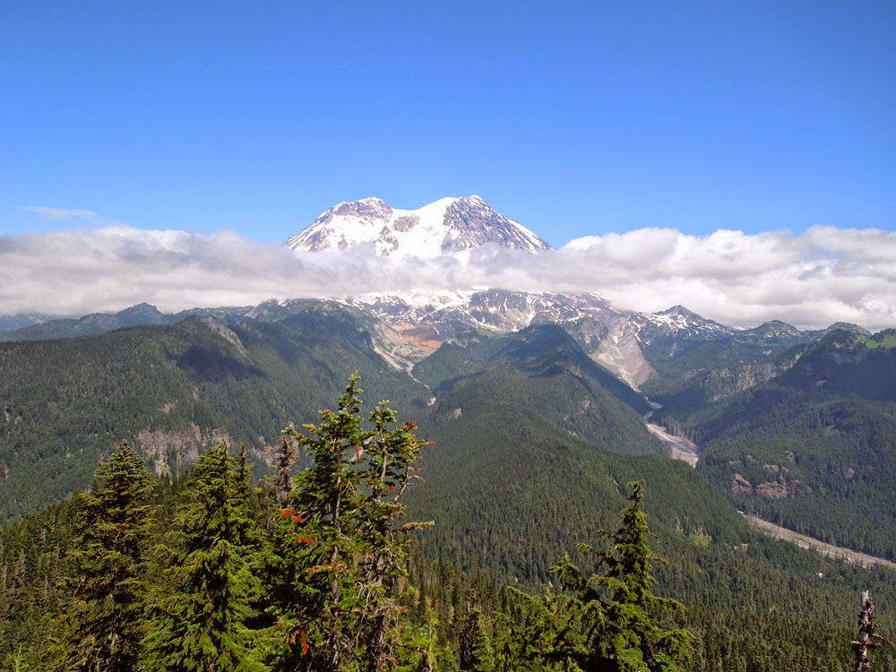
Here's the big reason to hike all this way.  The W side of Mt Rainier revealing the Puyallup and Tahoma glaciers.

Mt Defiance W7W/KG-043 July 19, 2013

Mt Defiance is one of the peaks along the I-90 Highway about 5 miles west of SnoqualmiePass.  Washington Trails Assn’s hike info here:  

To make up for running out of time, a week before, on the SOTA trek to Pratt Mtn (mostly the same trail but east of Mt Def) I hiked up the first 2 miles of the Ira Spring Trail way too fast.  This extra unneeded effort resulted in me being burned out for the last 700 vertical feet of ascent to Defiance.  In a way, getting to the top later than planned was a blessing because when I got there… the last of the other hikers who passed me were leaving and I had the whole summit to myself.  As the last hiker walked by, he heard the Morse code coming from my radios speaker and said he was surprised that anyone used it any more.  He told me that he learned Morse as a Boy Scout and was glad it was still alive.  His comments elevated my mood a bit.

The Mt Def. summit is a rocky approx 20 x 50 ft area with a few snow beaten scrub trees on its rocky top.  The tall trees, in case an activator was thinking of tossing a line up, are along the drop off part of the summit or down the trail a bit and not very accessible. 


Mt Defiance - the trail circles the the left side of Kula Kula Lake, up a ridge and then along the left slope of the peak.  I did not take this photo- it was harvested from the web.


The first thing I did was to remove my 2M antenna and HT from my pack and set it up.  I electrical taped my PVC pipe coaxial dipole to my trekking pole handle and jammed it into the ground.  My D72 HT was propped up against the pole.  I then heard a CQ on 146.520 from Mark K7MAS on 8 point Crystal Mtn (W7W/RS-010).  I stopped what I was doing to make this easy S2S QSO.  After that I heard Todd W7TAO calling me.  Wow, I thought Todd was on a nearby summit.  But no… he had been watching my APRS tracks from his home office and saw that I was on top…  Later in our 40M CW QSO, Todd told me that he was 70 miles from me which amazed me.  After that folks kept calling on 2M FM.  I finally had to announce that I must stop 2M FM for a while and concentrate on setting up my HF Station.


With nylon pack straps I secured my 18 ft fish pole to a scrub tree to support the center of my 44 ft doublet.  The ends were tied off to small trees with long lengths of mason line.  2 QSOs were made on 40M CW, 7 Qs on 30M CW, 17 Qs on 20M CW, and 11 Qs on 2M FM = 37 Qs total.  I sat in the sun for two hours and had the best SOTA outing (QSO wise, that is) yet.   It all sounds good… but some unplanned and unwelcomed experiences popped up that are worth mentioning.


The first thing that went wrong, before I arrived on the summit was my camera would not boot up.  It was disappointing because this is the most scenic summit I’ve been on since I went to the top of Old Snowy in the Goat Rocks 4 years ago.  This day could see for miles to the south to see Mt Adams and of course Rainier.  To the north I could see Glacier Peak, Mt Stewart and Baker.  It was a beautiful clear day.


Then I noticed that I was unable to send any APRS messages with my D72 HT.  Position/status reports yes, messages to SOTA for spotting- No.  APRS self spotting has always worked for me until now.

But wait!  There’s more… After operating my KX3 in the hot sun for two hours… it shut itself off right after the “HIGH TEMP” message scrolled across the display.  Oh Oh… I picked it up and it felt hot enough to drop it (but I didn’t).  Removing the battery connector and re-booting did not work.  So, I couldn't make that last SSB QSO with K7UYG who contacted me on 2M FM from some faraway place N and E of Ellensburg to arrange the contact.  I stowed the radio in its shady insulated lunch container case and picked up the rest of my camp site.


I was having so much fun making HF and 2M QSOs I did not notice that the hot sun was behind me and burning the back of my ears and neck, even after applying sunscreen.  I also didn't notice those little biting flies chomping on my legs.  

 
My GPS calculated the trip back to the TH was 5.2 miles with 3800 ft elevation loss which was an uneventful hike down except for running out of drinking water short ways before the car.


Epilog:  My KX3 manual has a short paragraph about the radio shutting itself off if it gets too hot.  I emailed a person I know at Elecraft and he mentioned that the VFO and PA monitors its temperature and will shut down or not allow boot up if it’s too hot.  The radio has performed just fine for a few outings since this one… and I am not concerned that the radio is damaged.  I ordered a new battery for my camera and a few spares that are now in my pack along with the spare GPS, headlamp batts, and D72 batt.  I am still puzzled about my D72 not reliably sending messages to the internet.  I suspect that something might be wrong with the local I-Gate digipeater(s) or their connection to the internet.  

Thursday, June 13, 2013

Rattlesnake Mtn - W7W/KG-113 - June 10, 2013

Rattlesnake Mtn is part of King County's "Big Backyard" series of  hikes.  There is a trail head at the northwest end of the mountain at Snoqualmie Point and at the southeast end at Rattlesnake Lake.  Walking from TH to TH is about 11 miles.  We took the Lake route which is 4.3 miles and gains ~2500 ft.  See:  http://your.kingcounty.gov/ftp/gis/web/vmc/recreation/BCT_RattlesnakeMtn_brochure.pdf

Myself, Ms Pat WT7N, and Chuck AC7QN hit the trail about 10:30 AM and arrived at the high point at 13:10 PDT.  There is a very old Comm Tower at 3517 ft ASL, about 150 ft from the trail.  We opted to set up away along the trail and away from the possible interfering comm tower at 3501 ft ASL.  

Local chasers were following me on APRS and once they knew I was at the summit (The D72A provides the frequency of the 'B' band in the APRS status message)... I began getting calls on 146.520.  4 stations were quickly worked on 2M FM.  I had to sign off of 2M in order to have time to set up my HF station.

I erected my 18 ft Crappie Pole with 44 ft doublet and attached the pole to a trail marker sign post.  I also attached my PVC pipe 2 meter Coaxial Dipole to this same post.  Mason twine tied to nearby trees elevated the ends of the doublet.

The black crappie pole is seen emanating from the trail sign post.  One red doublet wire is seen heading north.  It's hard to see the white PVC pipe vertical dipole also strapped to the post.  

This activation was my first use of the homebrew 44 ft doublet fed with TV twinlead and a homebrew 4:1 balun.  I operated 40M, 30M, and 17M CW.  I skipped 20M because Chuck AC7QN was set up nearby on 20M SSB.  We interfered with each other but I made my CW QSOs quickly and then he was able to work some SSB Chasers.


My KX3 and 2600 ma/hr LiPo battery are sitting on a piece of 1/4" plywood which is normally used as a lap-desk.  The TV twinlead and balun box are seen.  The Handy Talky is a Kenwood D72A for 2 meter QSOs- but mostly used for Spotting myself to sotawatch.org.


This my first time operating 40M on a SOTA outing.  3 local stations were worked but the highlight was Phil NS7P on SOTA summit W7O/WV-088.  30M and 17M provided a handfull of QSOs.  Thanks to all who followed my aprs tracks and made contact with me.  Here's a movie I created of Chuck AC7QN's activation of Rattlesnake Mtn:  http://www.flickr.com/photos/kr7w-sota/9020106340/in/set-72157634077239308


There is a bench at the summit that has this view looking east toward Snoqualmie Pass down the I-90 Corridor.  It's pretty scenic for being less than 30 miles from the metropolis of Seattle.

Happy Trails,
Rich KR7W