Monday, July 29, 2013

Gobblers Knob W7W/RS-050 July 28, 2013

Sunday, July 28, 2013 myself, Pat WT7N, her bro Mike, and Chuck AC7QN hiked to Gobblers Knob- which is located in Mt Rainier National Park, WA State.  There’s two ways to get to Gobblers Knob.  We chose the shorter route that approaches from the west via Forest Rd 59 instead of the longer Westside Road route.  See Washington Trails Assn’s hike info here: 


The fire lookout hanging over the summit edge.  Mr Cameraman was about 150 vertical feet below the summit.

To save a mile hiking… we did not turn off of FR59 to head to Lake Christine. We stayed on FR-59 all the way to a rock/dirt barricade across the road where the TH is marked by a FS rules and regs kiosk.  Follow the trail about 100 ft to the intersection and head right.  Walk .9 miles to the intersection with the Lake Christine TR 249.  Head east on TR 248 to Goat Lake.


TR 248 passes through some sweet and sour scenery.  The Beljica Meadow and Lake are unusually pretty on a nice day.  The lush green marshy meadow is a heaven for Mosquito breeding.  I had hundreds of the little buggers on my arms- like the old TV commercial for OFF bug spray.  A quick swipe removes them easily.  It's important to walk fast through this area to make your own breeze.  The trail continues a couple of hundred ft elevation gain and then loss continues through a dense tree cover to one of the sixty something Goat Lakes (or creeks or peaks) in the State of WA.  Goat Lake is very scenic and offers nice campsites, good fishing and I was told not very many bugs.  So far we have ascended and descended with a net loss of 300 ft in about 2.8 miles.  From this point the trail begins its approx 1300 ft ascent in 1.3 miles into the National Park and to the summit / lookout.

SOTA station set up in boulder rocks just N of the lookout.


The summit of Gobblers Knob is not a very big area and has steep drop offs on all sides.  The 14 x 14 ft lookout building covers most of it and the remainder is festooned with odd shaped boulders.  I did not want to attach my antenna to or detract from the appearance of the lookout for visitors sake, so I climbed over boulders to a location about 50 ft north. My 44 ft doublet was set up in Inverted Vee fashion with the push-up mast jammed in a rocky crack.  The wire ends were tied off to small trees.  My two meter PVC pipe coaxial dipole was also jammed into a crack with the D-72 at the base.  I operated my HF XCVR between two boulders and mostly out of the foot traffic way.  

Fish Pole in rocks to support Inverted Vee Doublet.  The pipe with the white base and brown top is a vertical coax dipole 2M antenna- jammed in a crack.  The 2M HT is at the base of the pipe.
Thousands of photos like this one... KX3 in insulated soft lunch box with Super Heros lunch carrier with an actual lunch in it.  Duck hunters insulated sit pad in lower left.

4 QSOs were made on 2M FM, 8 CW Qs on 30M, and 2 CW Qs on 20M.  I contacted the usual local hams that follow my APRS tracks, the usual chasers from around the country,  and a few new chaser call signs. 

Fellow ham Chuck AC7QN set up his half wave wire from the lookout railing and operated 20M SSB while I took a break and ate lunch.  After he finished I went back to 20M CW to continue on with 11 CW Qs and the last Q was a SSB contact with an Indianappolis Speedway Special Event Station, “I’ll putcha in the log as a QRPer, old man”. 

This trip resulted in way less equipment failures than the previous trip to Mt Defiance.  My camera booted up, my KX3 did not overheat and shut off, but the APRS messages I sent to SOTA for self spotting were not received by the internet again.

I’ve been to this peak twice now and each time the view of the west side of Mt Rainier is spectacular- well worth the effort even if you don’t take radios out in the woods.  Happy Trails -30- …. Rich KR7W

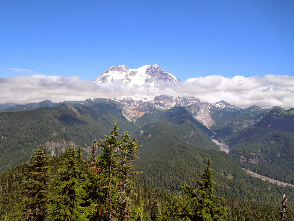
Here's the big reason to hike all this way.  The W side of Mt Rainier revealing the Puyallup and Tahoma glaciers.

Mt Defiance W7W/KG-043 July 19, 2013

Mt Defiance is one of the peaks along the I-90 Highway about 5 miles west of SnoqualmiePass.  Washington Trails Assn’s hike info here:  

To make up for running out of time, a week before, on the SOTA trek to Pratt Mtn (mostly the same trail but east of Mt Def) I hiked up the first 2 miles of the Ira Spring Trail way too fast.  This extra unneeded effort resulted in me being burned out for the last 700 vertical feet of ascent to Defiance.  In a way, getting to the top later than planned was a blessing because when I got there… the last of the other hikers who passed me were leaving and I had the whole summit to myself.  As the last hiker walked by, he heard the Morse code coming from my radios speaker and said he was surprised that anyone used it any more.  He told me that he learned Morse as a Boy Scout and was glad it was still alive.  His comments elevated my mood a bit.

The Mt Def. summit is a rocky approx 20 x 50 ft area with a few snow beaten scrub trees on its rocky top.  The tall trees, in case an activator was thinking of tossing a line up, are along the drop off part of the summit or down the trail a bit and not very accessible. 


Mt Defiance - the trail circles the the left side of Kula Kula Lake, up a ridge and then along the left slope of the peak.  I did not take this photo- it was harvested from the web.


The first thing I did was to remove my 2M antenna and HT from my pack and set it up.  I electrical taped my PVC pipe coaxial dipole to my trekking pole handle and jammed it into the ground.  My D72 HT was propped up against the pole.  I then heard a CQ on 146.520 from Mark K7MAS on 8 point Crystal Mtn (W7W/RS-010).  I stopped what I was doing to make this easy S2S QSO.  After that I heard Todd W7TAO calling me.  Wow, I thought Todd was on a nearby summit.  But no… he had been watching my APRS tracks from his home office and saw that I was on top…  Later in our 40M CW QSO, Todd told me that he was 70 miles from me which amazed me.  After that folks kept calling on 2M FM.  I finally had to announce that I must stop 2M FM for a while and concentrate on setting up my HF Station.


With nylon pack straps I secured my 18 ft fish pole to a scrub tree to support the center of my 44 ft doublet.  The ends were tied off to small trees with long lengths of mason line.  2 QSOs were made on 40M CW, 7 Qs on 30M CW, 17 Qs on 20M CW, and 11 Qs on 2M FM = 37 Qs total.  I sat in the sun for two hours and had the best SOTA outing (QSO wise, that is) yet.   It all sounds good… but some unplanned and unwelcomed experiences popped up that are worth mentioning.


The first thing that went wrong, before I arrived on the summit was my camera would not boot up.  It was disappointing because this is the most scenic summit I’ve been on since I went to the top of Old Snowy in the Goat Rocks 4 years ago.  This day could see for miles to the south to see Mt Adams and of course Rainier.  To the north I could see Glacier Peak, Mt Stewart and Baker.  It was a beautiful clear day.


Then I noticed that I was unable to send any APRS messages with my D72 HT.  Position/status reports yes, messages to SOTA for spotting- No.  APRS self spotting has always worked for me until now.

But wait!  There’s more… After operating my KX3 in the hot sun for two hours… it shut itself off right after the “HIGH TEMP” message scrolled across the display.  Oh Oh… I picked it up and it felt hot enough to drop it (but I didn’t).  Removing the battery connector and re-booting did not work.  So, I couldn't make that last SSB QSO with K7UYG who contacted me on 2M FM from some faraway place N and E of Ellensburg to arrange the contact.  I stowed the radio in its shady insulated lunch container case and picked up the rest of my camp site.


I was having so much fun making HF and 2M QSOs I did not notice that the hot sun was behind me and burning the back of my ears and neck, even after applying sunscreen.  I also didn't notice those little biting flies chomping on my legs.  

 
My GPS calculated the trip back to the TH was 5.2 miles with 3800 ft elevation loss which was an uneventful hike down except for running out of drinking water short ways before the car.


Epilog:  My KX3 manual has a short paragraph about the radio shutting itself off if it gets too hot.  I emailed a person I know at Elecraft and he mentioned that the VFO and PA monitors its temperature and will shut down or not allow boot up if it’s too hot.  The radio has performed just fine for a few outings since this one… and I am not concerned that the radio is damaged.  I ordered a new battery for my camera and a few spares that are now in my pack along with the spare GPS, headlamp batts, and D72 batt.  I am still puzzled about my D72 not reliably sending messages to the internet.  I suspect that something might be wrong with the local I-Gate digipeater(s) or their connection to the internet.